Q: What makes Plan Your Sail unique?
A: It lets you iterate quickly
There are plenty of tools for sailors to use to check Tides and Currents – the NOAA websites, Navionics, special-purpose Apps, even the old standby tide book. I use many of these routinely, and one thing I found is that I couldn’t iterate quickly enough when looking for the right date and time to do a trip.
That’s why I built Plan Your Sail.
In Plan Your Sail, “Transits” are just stored templates for a trip you plan to take. When you open a Transit, you can easily pick the Date and Time right at the top of the screen, and the App instantly updates the predictions for Tides and Currents at every Waypoint along your route.
So you can quickly see if conditions are right on that date and time for your sail, and, if not, pick another day.
Since you can save lots of different templates (Transits), you can also quickly answer the question “Where is the best place to sail today?”
Q: What is a typical scenario for using Plan Your Sail?
A: Here’s a typical use case: planning an overnight sail to Clipper Cove in the San Francisco Bay
There is a shoal along the entrance to Clipper Cove, making the entrance quite shallow. At low tide, it can be well below five feet. To plan an overnight stay in Clipper Cove, you need to know Tide predictions for your arrival time, as well as your departure time the next day.
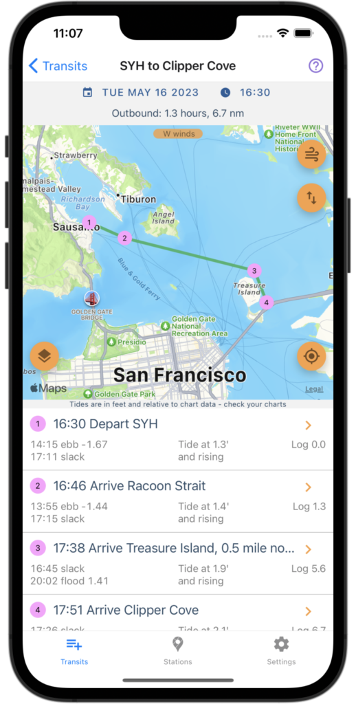
In addition, the SF Bay has strong currents due to Ebb and Flood Tides. Ideally, you’d have these currents running with you or at least not running against you. The screenshots below show a Transit to Clipper Cove.


We can see that we’ll be making the transit towards Slack tide, which means we won’t be fighting an ebb current. That’s good!
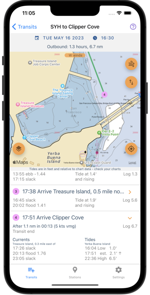
Also, the tide will be 2.1′ and rising at the entrance to Clipper Cove when we arrive. In the second image, we zoom in to Clipper Cove with the Chart overlay, which shows depths at MLLW. The shallowest depth shown at the entrance is 3′, which, when added to the 2.1′ tide, gives a depth of just over 5′. Plan your trips carefully!
Q: Can I move a Waypoint?
A: No
We haven’t implemented move (yet). You can remove the Waypoint from your transit and create a new one. Note that unused Waypoints (Waypoints that are not present in any Transit) will automatically be deleted.
Q: Can I reorder Waypoints in a Transit?
A: No
We haven’t implemented that yet either.
Q: That’s super dumb. What gives?
A: Meh, just priorities
I use Play Your Sail for my own trips, and I’ve found that I build Transits infrequently but I use transits often. So, I optimized my development effort around using Transits to plan rather than creating and editing transits. They’re pretty quick to build anyway.
Q: Can Transits be renamed?
A: Sadly, no
Transits are automatically named using their first and last Waypoint, e.g., “Sausalito to Berkeley”. There is no way to rename a Transit.
Q: Can I reorder Transits in the Transit List?
A: Again, no
Transits are listed alphabetically.
Q: Why doesn’t Plan Your Sail show wind conditions?
A: Wind and weather conditions are difficult to predict in advance
Fundamentally, Plan Your Sail is a long-range planning tool. It helps you pick a date and time to sail to a destination given the constraints of Tides and Currents, which can be predicted well in advance. Of course, as the date approaches, wind and weather conditions will become important, and there are plenty of good weather apps for sailors to use to get those predictions.
Q: Is there a way to create Waypoints outside of Transits?
A: No, Waypoints are always associated with one or more Transits
Waypoints can be used in multiple Transits, but there is not way of creating a “library” of Waypoints independent of Transits. When you remove a Waypoint from all of the Transits in which it is used, that Waypoint is deleted.
Q: Why not call them “Routes”
A: Good question
No particular reason. Routes would probably have been better.
Q: Why is there only one setting for Boat Speed?
A: It’s just an estimate
We’re not trying to be exact, just to give an estimate for how long a trip will take based on your average boat speed. The app provides a couple of extra settings to handle legs in which you’re sailing upwind: Upwind factor and Minimum angle to wind (see the discussion in How To Plan Your Sail under “Changing the Wind Direction”.
Q: What if I plan to motor-sail when going upwind?
A: We thought about that!
If you press and hold the Wind icon at the upper right of the map, It will turn on “motor sailing” mode, which disables the calculations for sailing upwind and simply uses your Boat Speed for every leg. Press and hold again to turn off motor-sailing mode.
Q: Are Transits saved in the Cloud?
A: Nope, everything is saved on your device
You don’t need an account to use Plan Your Sail. Everything is saved on your device. Of course, this means that if you have more than one device, you’ll have to re-create all your Transits.
Q: That’s super dumb, isn’t there some way to transfer Transits to another device
A: Well, actually… yes, but it ain’t pretty
If you go to “Settings->Transits Data->Show Transits” you will see the JSON data for all your Transits. You can export them by pressing the Share button on the lower right of the screen.
You can also import Transit data by going to “Settings->Transits data->Import”. Import will automatically read the Clipboard and show a list of Transits that it finds.
So, you could:
- Export Transits from your old device, and save to a file or email
- On your new device, copy the exported Transits as text from the file or email to the clipboard
- Import the copied Transits on your new device
You can share Transits with other people using the same technique. I told you it wasn’t pretty.
Q: Why not just have a cloud account with my Transits?
A: Ugh. Better things to do
OK, it’s not a bad idea. Maybe someday.